
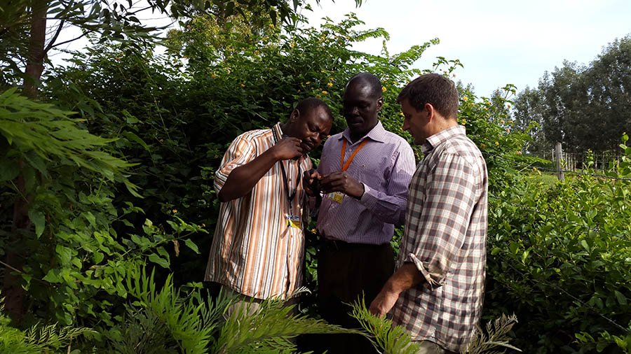
Feature photo: After receiving training from Brian (right), Nyangi (left) trains Andrew (center) on how to plot out the boundaries of a Nuru Kenya farmer’s land on Google Maps using a wrist-mounted GPS navigator.
Maps record the current world. They depict what is known, capturing a freeze frame of life in mid-beat. The course of wars, the path of revolutions, the birth of new nations, and the fall of empires are inscribed in country names and border lines.
Maps have the power to inspire. I spent hours as a child poring over maps in National Geographic, dreaming of the far off worlds that I saw in exotic pictures. Even fictional maps, like those hand drawn in Lord of the Rings, captured my imagination. When I studied ancient history in high school, I felt more connected to the maps of battlefields than to the narrative. Flipping through a modern atlas and seeing the same ground today where history was made allowed me to envision the heroes of old. Even today, I still have the combat-torn map I carried with me in Operation Iraqi Freedom that kept my platoon and me safe.
Maps project the future. They show the geography of change. Here in Kenya, the map of Nuru’s progress depicts the erosion of poverty’s contour lines, displays the growth of crops in the farmer’s fields, and plots the location of farmers whose lives are improving one year at a time. The geography of Nuru Kenya shows the growth of hope against impossible odds.
My visit to Nuru Kenya over the last few months couldn’t have come at a more exciting time. The Foundation Team is preparing to transition out of the project to allow the local Nuru Kenya staff, an exceptional group of leaders, to carry on the impact programs and scale the Nuru model to throughout Migori County. As part of my contribution to this transition, I’ve worked closely with two community outreach members, Nyangi and Andrew, to map the progress Nuru Kenya has made over the last seven years. Using Google Maps, we captured much of the impact work that the Foundation Teams, Nuru Kenya staff, and most importantly the farmers, have done.
First, we plotted the location of the Village Aggregation Centers (VACs). These are the granaries where Nuru farmers store excess crop after the harvest to either sell for profit or use later for food. There are seven now when there were once none. Mapping the VAC locations helps us ensure that all Nuru farmers have access to at least one center. These centers are an indicator that farmers are actually harvesting more than they need using better seed and improved planting practices. This is a critical rung on the ladder leading out of poverty.
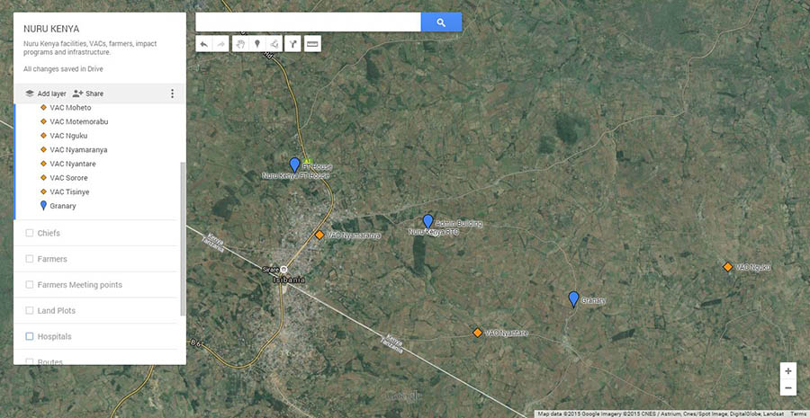
Next, we mapped the offices of the chiefs of the region. These men are official government representatives and responsible for different areas in Migori County. They work with the police to maintain security and are the primary arbiter resolving disputes between farmers and between clans. Earning the trust of these key leaders is critical to gain access to a community and reach households in that area.

Soon, Nyangi and Andrew will draw out the land plots of each Nuru farmer onto the map. This visual depiction of the farmers, their lands, the chiefs, and the Village Aggregation Centers will be the base map that all future staff members will add to as Nuru scales across the country. Nuru Kenya will continue to update the map every year, adding new farmers, noting changes for better or worse, and recording the ebbs and flows of progress as hope springs forward with every harvest.
There is endless potential for future use that will enable Nuru Kenya to clearly track and see its work, making them more efficient and effective. The Agriculture Field Officers will color code the fields, showing red for poor crop yield and green for high yield. Tracking crop yields and pointing out early signs of crop disease can provide early indicators of trends that will affect the whole region. The farmer savings groups will be tracked by the Financial Inclusion team to determine how well farmers are managing their money and repaying loans. The Community Health Workers will track sickness in the households to provide much needed geo-located statistics on the state of health of the entire area. Literacy rates will be overlaid onto the map to determine where the Education Program needs to focus its efforts. This information will enable the staff to bring help to where it is needed most. Nuru Kenya has the potential to be the most valuable source of agriculture, financial, health and education-related information in the country.
As Nuru Kenya expands its impact programs throughout Migori County, and eventually throughout the country, the maps will serve as a historical tapestry of the tireless struggle against extreme poverty. By showing how far we have come, the map of Kenya’s landscape today inspires everyone at Nuru to boldly forge ahead towards the unseen lands of the future, with hope as the only guide, breathlessly anticipating what the map of tomorrow will show.